
Principles of Geology for Readers of Part III
Part three of The Urantia Book provides a concise, revealed account of the deep history of the Earth and the life that evolved here, and this account is remarkable both for its resemblance to the findings of conventional science and for its surprising points of difference. Although the identification and attempted resolution of such anomalies is interesting enough to pursue, I suggest that where science is concerned it is more rewarding to concentrate on the principles upon which our science has been built.
On this occasion I have in mind that the respectability of geology as a science comes from around two hundred years of applying what Charles Lyell called “The Principles of Geology” which became the title of his three-volume series of books (published 1830-1833). These principles are not laws to be obeyed, nor are they a strict recipe for manufacturing geological wisdom out of a pile of rock samples. Nor are they even very profound, yet these generalizations about the Earth’s processes have a way of tuning the mind for better observation and discovery sufficient to withstand all manner of strange ideas without too much upset.
Through these principles the Earth has shown itself to be accessible to human inquiry, big enough to be sometimes mistaken as a universe but not utterly beyond comprehension. We can proceed with reasonable expectation that the same principles can also be extended to guide us in understanding what we read in part three of The Urantia Book. We have available for our consideration two hundred-year spans of geology neatly balanced at the point of emergence of The Urantia Book in the nineteen-thirties.
Firstly we’ll consider the principles themselves. Then I think we can improve upon the usual popular science coverage of geology by taking on two of geology’s important findings. One is to find the age of the Earth in millions of years, because before mid-twentieth century such a feat was tantamount to sorcery, and also because Part III does make frequent mention of numerical ages. The other is to explain the origin and continuous re-generation of mountains, because it is so strange to imagine that their explanation could be any harder than so many other origin stories: volcanoes, petroleum, groundwater, gold, or even, in general terms, the Earth itself.
Under the Green and Pleasant Land
Charles Lyell (1797-1875) had the important advantage of living in Britain where there was so much that was conducive to developing practical and theoretical geology. Mining, especially coal, iron and tin provided economic incentive and beyond the mines there were all the quarries, tunnels and embankments associated with the rapidly expanding network of canals and railways so, quite simply, more digging meant more rock upon which to cast a discerning eye. In fact there is hardly any better window into the earth than a railway embankment, except perhaps a modern open-cut mine.
Indeed, rail travel from central Melbourne to this year’s conference presented this speaker with an opportunity to re-experience the wonderment of a nineteenth-century geologist. At the embankment somewhere near Rosanna Station I first noticed a yellow sandstone with very obvious hard and soft layers, nearly horizontal. At the next few sightings on the way to Greensborough the layers appeared tilted and then folded into an attractive wavy pattern.
The completely deliberate, orderly deposition of every sand grain is the relentless work of Nature, ever ready to preserve a landscape feature, such as a river sandbank or a beach, in sufficient detail as to capture the pattern of sand spilling over itself or being washed into waves by current. To notice that rock can be pressed so firmly for such a long time as to fold like that without breaking is also to be confronted with the need to comprehend immense tracts of time, tens of millions of years at a glance, and at least hundreds of millions of years for the Earth as a whole.
For the geologists of Lyell’s day, the immensity of time was probably unsettling, but under their green and pleasant land there was also evidence of great, fiery upheavals in the past; volcanoes and lava flows and great bodies of rock that must have crystallized in place from a completely molten state. As a result, in their interpretations of Earth processes, early geologists were undecided between dramatic and steady, between catastrophic and gradual, between fiery and watery, as expressed in the explosiveness of the volcano and gentleness of fine grains of sand settling into repose under water. But the general wisdom eventually came to be that since there are plenty of examples of extremes and intermediates it is more useful to notice what repeats reliably rather than what happens dramatically one time only, thereby favouring process over spectacle. This deceptively simple principle goes by the name, “uniformitarianism” and it is remarkable how much the success of geological science rests upon the apparently subtle distinction between a broad, conceptual uniformity of well-defined processes, which is helpful, and ordinary uniformity in all particulars, which is overwhelming. In the case of a volcano, for example, instead of being overwhelmed the uniformitarian principle means going straight into the useful work of comparing it with other volcanoes from the past.
The philosophically minded observer will notice also how uniformitarianism resonates with the prevailing early nineteenth century faith in the integrity of all creation.
The uniformitarian comprehension of time and slow accumulation of change is also seen in Charles Darwin’s explanation for the evolution of life and probably informed by Darwin’s own contribution to geology involving the gradual transition from simple ocean volcano to one encircled by coral reef and from that to one submerged with only the circular coral reef visible as an atoll.
The expression of confidence derived from the uniformitarian mind-set is seen in another of geology’s great activities called “correlation” which extends the principle to anticipate the Earth’s tendency to operate with characteristic uniformity of process in space as well as in time, such that similar conditions are producing similar rocks in different places.
In my example of embankments en-route to this conference it would have been completely natural and intuitive to “join the dots” between the embankment at one station and the next to infer that about the same sequence of rock was seen, but folded by different amounts.
It happens that the Earth is quite amenable to this kind of interpretive activity and, in the south of England and Wales, very amenable indeed. If the sediments had remained horizontal as they were formed only the top-most layer would ever be accessible without digging, but in Southern England the layers are tilted at a convenient angle and planed off by erosion to bring the whole stack nearly into view with only plants and soil in the way.
It becomes easy to entertain the notion that the Earth wants to reveal itself to the patient observer.
The successful correlation of rock types over such a wide area is seen in the remarkable geological map created by William Smith in 1815. This was joining the dots on such a grand scale as to discern correspondingly large periods of time, and changes in character so significant as to mark stages in the actual evolution of the Earth. Gradually, with the aid of fossil evidence, correlations of the main sedimentary sequences were extended over the entire Earth and its various times of prevailing desert or prevailing ocean or coal-producing forest. Sometimes a global event, such as a large meteorite impact also inserts a very helpful marker into the sedimentary sequence.
With knowledge about large parts of the Earth it became possible to recognize the long periods of similar conditions known as the geological periods. And so we have the familiar wall-chart showing the geological periods which condenses a multitude of sequences from around the world into one great imaginary cross-section decorated with fossil plants and fossil animals; a conceptual and graphic marvel.
Nineteen Thirty-Four
To summarize the state of geology at around the time of the Urantia Book‘s arrival in 1934, the sequence of events was well-defined, and the immensity of time was understood, and there had been attempts to estimate the age of the Earth from how long it would take to cool from a completely molten state, but these estimates were always far too short.
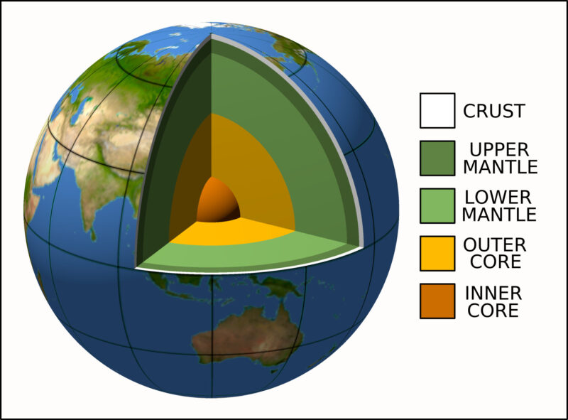
One great achievement from around the 1930’s is that seismic waves had been used to infer the internal structure of the Earth down to its solid core along with the surprise discovery of a thick outer core layer of super-dense liquid. That surprise comes from the two different ways in which distorted rock springs back to push seismic waves along, but in a liquid one of those ways does not happen and the corresponding seismic wave will not make it through. As unlikely as it seems that such a subtle, deeply hidden detail could ever be known, in principle it is as simple as waiting for an earthquake to make the seismic waves and marking out the seismic shadow cast over the part of the Earth that cannot be reached by those waves that cannot penetrate the liquid sphere within. Of course, some considerable computational effort was also needed and probably a few worn out slide rules to deal with the important complication that the seismic waves also bend or refract as they travel through the body of the Earth.
This new information about the interior of the Earth was soon captured in an impressive diagram showing the sphere of the Earth cut away to expose its layers, now a familiar feature in popular science and education about as iconic for the 1930’s as the cross-sectional chart of the geological periods is to the 1830’s.
Also, by the 1930’s, much had been learned about how minerals crystallize from the molten state through an orderly sequence of chemical exchanges even though that deep, high temperature, high pressure environment is completely inaccessible. In this case the information was obtained by careful microscopic examination of the cooled resulting minerals, their compositions, and their relationship to each other, combined with laboratory experiments with apparatus to put small samples under the necessary extreme temperature and pressure.
Compared to ice crystals forming in liquid water the process is similar, but the underground liquid rock is much more complicated in its chemical composition. Whether it’s water or liquid rock, if cooling happens slowly enough each atom has time to find its near-perfect place on the surface of a growing mineral crystal. For a given chemical composition, the sequence of minerals that crystallize is completely reliable, with each particular mineral selectively taking atoms from the liquid and leaving behind a composition suitable for the next mineral in the sequence.
Further complications are that some denser minerals drop to the bottom of the fluid, sometimes fluid escapes and the sequence has to adjust accordingly, and some chemical elements, usually metals such as gold and platinum, don’t belong in many minerals and these become the last of the fluid to solidify, small in volume and relatively pure.
Findings and Anomalies
By the 1940’s, while The Urantia Book itself was continuing to “crystallize”, the necessary electronic instrumentation became available to finally take the great nineteenth-century wall-chart of geological time and write some numbers on it denoting ages in millions of years by applying relatively new knowledge about radioactivity.
Incidentally, radioactivity produces heat which made the Earth cool much slower than it would have. Early estimates of the age of the Earth were so wrong on the low side because they didn’t allow for this unknown heat source.
Measuring time with radioactive atoms in a rock can be likened to counting grains of sand falling through the stem of an hourglass, except that in the rock the count is much more demanding because among the rock’s many atoms there are hardly any radioactive ones to begin with and even fewer at the end.
Given the proper electronic instrument to sort and count and the right kind of atom, one that decays fast enough to show a result but also slow enough to keep “ticking” for long enough, the age of the rock in absolute millions of years can be computed, allowing that the overall rate of decay (atoms per unit time) keeps changing, proportional to the number of radioactive atoms whereby the relationship between count and time is logarithmic rather than linear.
With the age of the Earth out of the way, let’s now consider the problem of the origin of mountains which evaded satisfactory explanation for so long. Very obviously every grain of sand must come from somewhere higher up as surely as the water that washes it there but the problem shows itself properly when it is realized that although many a mountain’s worth of sediment has already been washed away there are still mountains. Moreover, the many mountains that consist of sediment that must have been available in huge volumes beforehand and that also needs some explaining because sediment can’t accumulate unless the Earth keeps subsiding to make space for it.
The often-repeated association between great ranges of mountains and great basins of sediment is so similar in scale, and so sequential in time that it seems reasonable to suggest either a common cause for both or that the one phenomenon might be causing the other. Without being sure about the cause, a concept was formulated to put mountain, basin and cause together in a tight, virtually cyclic, sequential relationship and it is called the “geosyncline”; syncline being the technical word for a down-folded region and geo being a prefix indicating mountainous in size. The geosyncline concept was very usefully extended to many other associated phenomena and their timings, such as types of volcanoes, structural folds and faults, intensity of metamorphism, placement of economic minerals, maturation of coal deposits and petroleum reservoirs. In various places entire sequences of geosynclines have been traced, however the concept could not fully discover what could actually drive the Earth down in one region, allow sediment to accumulate, and then drive it back up again. The origin of mountains remained stubbornly unexplained, awaiting further developments.
Some of the geology we read in Part III retains artefacts from this conflicted period during which the limitations of the geosyncline concept were apparent and yet the idea of “continental drift” remained controversial.
For example, (from 57:8) there is an important observation that the dramatic division between high-density, low-elevation ocean crust and low-density, high-elevation continental crust described in a way that resembles modern geology. Yet it makes a claim that deepening of the ocean floor was somehow promoted by dense material from meteorites spilling off the continents. To this I say that any dense meteorite spilling off the land would not travel very far offshore, therefore failing to explain depression of the greater ocean floor. I will point out that neither is it so easy for meteorites scattered over the land nor make it to the ocean since, as every gold prospector knows, it is the denser material that doesn’t transport very easily.
Now, one of the old objections to the idea of continental drift has to do with the mechanism, as there are limited options for applying the necessary force to a continent without warping it or tearing in a way that is inconsistent with observations. With this in mind, I think the logic (in 58:5) leading to the inference that “differential pressures tend to cause the continents to slide towards the ocean beds” is an unconvincing attempt to have the continents creep along by force developed within, whereas in reality continental margin slopes are gentle enough to accommodate differential pressure at every depth. Afterall even on the moon against no balancing force from water nor air, an ordinary cliff face will either stand vertically for a while or crumble until it forms its own balancing slope.
How or why such anomalies exist in The Urantia Book is hard to say except perhaps to suggest that when an antiquated term such as “continental drift” appears as a heading, the author is signalling content soon to become obsolete: reader beware.
Happily, these anomalies in The Urantia Book and many others of our own invention are now resolved within the modern theory of plate tectonics. The activity it describes whereby “plates” of continent or ocean, mobilized by flowing under-currents in the mantle, continually tear apart and collide and ride over each other in interesting ways; to form the sedimentary basins, to build the mountains, to sprout the volcanoes and everything else that follows, all at a rate that is fast enough to be interesting but not too dangerous for the inhabitants.
Geologist in Spirit
I have suggested a few geological principles that seem to tune the mind for better observation and discovery of Earth processes. They also seem to tune the mind of the geologist into sympathy with the deep creativity underlying the natural world which might be why one geologist at University of Queensland wrote an unusual, philosophical epilogue to a book that he wrote. I quote it below as an apt example of meaning being perceived directly from the natural world by a suitably tuned mind. It will help if I first decode that the symbolic pink lotus on its pad is being taken to physically resemble the upper-case Greek omega, the symbolic stick plant is the ancient Protolepidodendron whose branched shape is being taken to resemble the lower case Greek alpha, and the Great Basalt Wall is a literal geological feature beside the Burdekin River in North Queensland.
The complexification process which is life itself has acquired Man as its consciousness. What are his energies being directed towards?
In symbolic terms it is the derivation of the sacred, scented Pink Lotus of the Great Basalt Wall from the Devonian “Stick Plant”.
The Alpha of elementary particles and energies is being assembled into an infinitely diverse and pervasive organization, which is being compressed by interrelationships towards a super-critical state at the point Omega. The spiritual energies at that point are known to Him alone. We can only seek them in Faith, as they are as incomprehensible to us as atomic energy would be to the cave man.
— Eric Heidecker,
“Reading Landscapes for Resources, Recreation planning, Survival, 1981”.